Hydrographic Surveys are conducted for obtaining information on water depth in Ports, Anchorages, Rivers, Inland-water ways, Dams, Reservoirs etc., and is required for Navigation, project-cum-engineering, irrigation, tidal power, tourism, inland water ways, pre-dredging, progressive and post-dredging, Siltation, erosion, pollution, flood control etc.
The data gathered is used to make informed decisions of several types: for example vessel navigation decisions; resource management decisions; resource development decisions; marine infrastructure decisions; marine construction decisions; coastal development decisions; tactical and strategic military decisions and environmental management decisions.
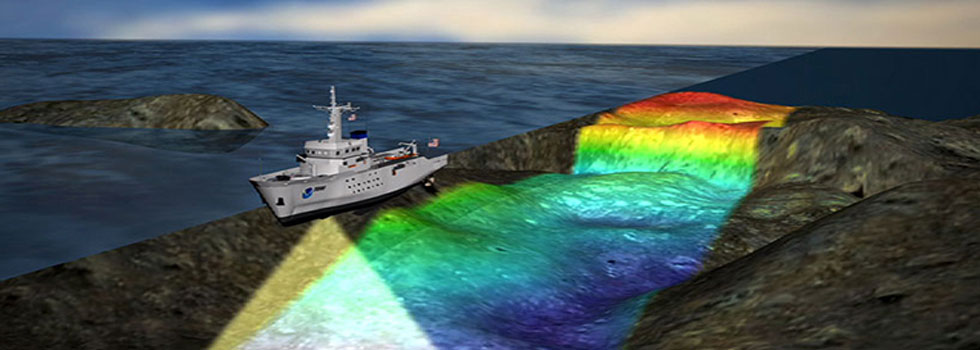
Though single beam surveys are more popular and are a de facto in hydrographic industry, constant improvements in hardware, software, computing power and cost effectiveness are making multi-beam surveys more popular. In comparison to the conventional single beam surveys, multi-beam surveys map the seabed faster and with greater precision and resolution.
The IHO Standards S44 4th Edition classifies surveys into four different types (four 'intended uses') as detailed below:
Special Order hydrographic surveys cover areas where ships may need to navigate with minimum under keel clearance and where the bottom characteristics are potentially hazardous to vessels such as boulders or rock outcroppings. This Order survey requires higher accuracies than those previously specified and for that reason has been particularly controversial. Special Order surveys are only applicable to those areas specifically designated by the Member State’s agency responsible for the survey quality.
Inherent in the requirements are closely spaced survey lines with side-scan sonar, multi-transducer arrays or multi-beam echo sounder arrays to obtain "100% bottom search". This term was adopted after numerous discussions on the impreciseness of the previously proposed term “100% personification”.
Order 1a
This order is intended for those areas where the sea is sufficiently shallow to allow natural or man-made features on the seabed to be a concern to the type of surface shipping expected to transit the area but where the under-keel clearance is less critical than for Special Order above. Because man-made or natural features may exist that are of concern to surface shipping, a full sea floor search is required, however the size of the feature to be detected is larger than for Special Order. Under-keel clearance becomes less critical as depth increases so the size of the feature to be detected by the full sea floor search is increased in areas where the water depth is greater than 40 meters. Order 1a surveys may be limited to water shallower than 100 meters
Order 1b
This order is intended for areas shallower than 100 metres where a general depiction of the seabed is considered adequate for the type of surface shipping expected to transit the area. A full sea floor search is not required which means some features may be missed although the maximum permissible line spacing will limit the size of the features that are likely to remain undetected. This order of survey is only recommended where under-keel clearance is not considered to be an issue. An example would be an area where the seabed characteristics are such that the likelihood of there being a man-made or natural feature on the sea floor that will endanger the type of surface vessel expected to navigate the area is low.
Order 2
This is the least stringent order and is intended for those areas where the depth of water is such that a general depiction of the seabed is considered adequate. A full sea floor search is not required. It is recommended that Order 2 surveys are limited to areas deeper than 100 metres as once the water depth exceeds 100 metres the existence of man-made or natural features that are large enough to impact on surface navigation and yet still remain undetected by an Order 2 survey is considered to be unlikely. The vertical and horizontal accuracy requirement of the IHO is summarized as follows: